

Features ImageOverlay
Due to the slow update of google map, this App provides an image overlay feature that allows users to upload taken images(from drone for example) and overlay them on google map.
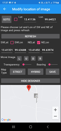
Users need to specify SW(southeast) and NE(northeast) coordinates(lat and lon) for the image.The App provides features to move the image (Left, Up, Down, Right, Rotate) and change transparency level so that the image can exactly match the background.
Also, the controller can be hidden so that the map can be displayed with full screen.Users then can keep track the progress of farming or construction by creating a collection of overlay images.
Version5.1 provides enhanced functions for ImageOverlay application: 1.
Allow users to overlay multiple images (user needs to choose an image one by one) 2.
User can save selected image (press "save" button on "Modify Location of Image" page) 3.
User can set SW and NW border points on map ( user needs to select related checkbox to enable this function before choosing a point on the map, to disable this function uncheck the checkbox) 4.
User can view a list of selected images by pressing "Saved Images" button, long press an item to remove an image.
Secure & Private
Your data is protected with industry-leading security protocols.
24/7 Support
Our dedicated support team is always ready to help you.
Personalization
Customize the app to match your preferences and workflow.
See the ImageOverlay in Action


Get the App Today
Available for Android 8.0 and above